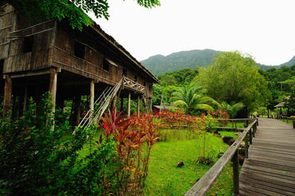
Translate

Friday 14 September 2012

Place that I want to visit (hopefully in the future)

Bario

Bario is a Malaysian village located in the centre of the Kelabit Highlands in the north east of Sarawak, very close to the international border with Indonesian Kalimantan, and 3280 feet above sea level. It is the main settlement in the Kelabit Highlands. There are regular flights between Bario Airport and Ba'kelalan, Marudi and Miri.

History

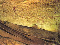
Over a century ago, the Kelabits were somewhat involved in headhunting raids, not so much for ritual purposes but as a means to prove one’s courage, bravery or valour, and to get even with their enemy. However, things have changed. Today among other things, the Kelabits are well known for their friendliness and hospitality. They embraced Christianity during the 1940s through the influence of Guru Paul, also known as Nimang Tepun.

In the year 1946, the first school was opened by Tom Harrison, who lived with the Kelabits for two years after the Second World War. In the year 2001, the Bario community was named as one of the Top Seven Intelligent Communities by World Teleport Association.

People

The Kelabit, at approximately 5000 people, is one of the smallest ethnic groups in Sarawak. Like many other indigenous communities in Sarawak, the Kelabit live in longhouses in the highlands. However, due to economic and social factors, many have migrated to live in urban areas over the last 20 years. It is estimated that roughly only 1200 Kelabit are still living in the highlands. The Kelabit language is widely spoken, and many have also learned to speak English and Malay.

Location

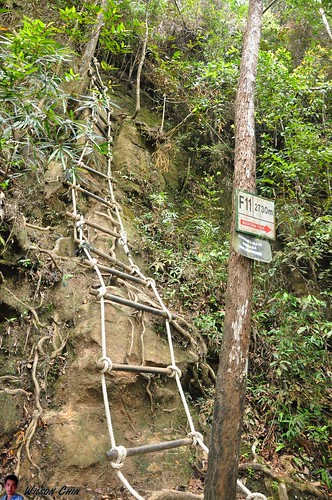
The Kelabit Highlands is tucked in the north eastern of Sarawak and is very close to the international border between Kalimantan and Sarawak. Bario is located on the Kelabit Highlands, 3280 feet above sea level. It is the unofficial capital of the Kelabit Highlands. All roads lead to Bario. Due to geographical barrier, this wonderful place is isolated from the rest of the world.

Unique


Handicraft
The Kelabits value ceramic jars, brass gongs and beads. These items are inherited from their ancestor. The beads are used to make beaded hats (peta baa' rawir) and necklaces that are worn by the Kelabit women especially on special occasion. Visitors can purchase some of these beads as souvenirs too.

Musical instruments
A traditional musical instrument is the sape', a plucked lute instrument. It is carved from tree trunk in an elongated rectangular shape with a homogenous neck extending from one end of the body. Formerly, its three or four strings were made from finely split rattan, but today they are made of wire strings.
The Kelabit also play the pagang (tube zither), which is made from a length of bamboo tube closed at both ends by its natural bamboo nodes. The strings are finely cut strips from the surface of the bamboo tube itself, which are still attached to the tube at either end. On special occasion such as Iraus or during visits by VIPs (Very Important Persons), the school children will form a bamboo band where all the musical instruments that are played are made from bamboo.
In 1946 the first school was opened by Tom Harrison, who lived with the Kelabits for two years after the Second World War. In 2001 the Bario community was named as one of the Top Seven Intelligent Communities by World Teleport Association.


Interesting places in Miri

1. Gunung Mulu National Park
2. Niah National Park


1. Gunung Mulu National Park


Gunung Mulu National Park near Miri, Sarawak, Malaysian Borneo, is a UNESCO World Heritage Site that encompasses caves and karst formations in a mountainous equatorial rainforest setting. The park is famous for its caves and the expeditions that have been mounted to explore them and their surrounding rainforest, most notably the Royal Geographical Society Expedition of 1977–1978, which saw over 100 scientists in the field for 15 months. This initiated a series of over 20 expeditions now drawn together as the Mulu Caves Project
The national park is named after Mount Mulu, the second highest mountain in Sarawak.

Geology

Gunung Mulu National Park is famous for its limestone karst formations. Features include enormous caves, vast cave networks, rock pinnacles, cliffs and gorges. Gunung Mulu is a sandstone mountain rising to 2377m.

Gunung Mulu National Park has the largest known natural chamber or room - Sarawak Chamber, found in Gua Nasib Bagus. It is 2,300 feet (700 m) long, 1,300 feet (396 m) wide and at least 230 feet (70 m) high. It has been said that the chamber is so big that it could accommodate about 40 Boeing 747s, without overlapping their wings. The nearby Deer Cave was, for many years, considered the largest single cave passage in the world.


Other notable caves in this area are Benarat Cavern, Wind Cave, and Clearwater Cave; which contains parts one of the world's largest underground river systems and is believed to be the largest cave in the world by volume at 30,347,540 m³.

 Mulu's limestones belong to the Melinau Formation and their age is between 17 and 40 million years (Late Eocene to Early Miocene).

Stratigraphically below the limestones, and forming the highest peaks in the south east sector of the Park including Gunung Mulu, lies the Mulu Formation (shales and sandstones). The age of these rocks is between 40 and 90 million years (Late Cretaceous to Late Eocene).

Fauna

Eight species of hornbill have been spotted in Mulu including the Rhinoceros Hornbill Buceros rhinoceros which features on Sarawak state emblem, the White-crowned Hornbill Berenicornis/Aceros comatus and the Helmeted Hornbill Buceros vigil with its large solid casque (bill).

Twenty seven species of bat have been recorded in Mulu. Deer Cave in the southern limestone hills of the park is home to an enormous colony of Wrinkle-lipped bats (Tadarida plicata). The bats exit the cave almost every evening in search of food in a spectacular exodus. A huge mound of guano in the cave is evidence of the size of the bat colony that roosts in the cave's high ceilings.

Mulu's mammals also include the Bearded pig Sus barbatus, the moonrat Echinosorex gymnurus, shrews, the Bornean Tarsier Tarsius bancanus, the long-tailed Macaque Macaca fascicularis, gibbons, squirrels, and three types of deer including the small barking deer and mouse deer. The small Malaysian sun bear Helarctos malayanus, which is the only bear known in South-East Asia, has also been identified in Gunung Mulu National Park.

Flora

Gunung Mulu National Park contains a large number of plant species, including flowering plants, trees, and fungi. Geology, soil types and topography have given rise to a rich tapestry of plant zones and types. On Gunung Mulu itself these include lowland mixed dipterocarp forest, lower montane forest, mossy or upper montane forest and summit zone vegetation on the highest peaks. On thelimestones there is lowland limestone forest as well as lower and upper montane limestone forest. Other plant communities dominate the alluvial plains, including kerangas (tropical heath forest) and peatswamp forest.

The Bat Exodus

Twelve species of bats have been recorded within Deer Cave, including the colony of Wrinkled-Lipped Bats estimated to number between 2.5 and 3.5 million individuals.

While you wait in the Bat Observatory for the nightly flight of bats to begin you can watch the secret life of millions of bats on MULU BAT CAM a remote controlled, closed circuit TV system which takes you into the dark recesses of the cave to observe the bats ‘live,’ up close and sometimes a bit personal!. 


Expectation builds as the sun moves towards the horizon and the Bat Hawks take up their roost on the cliff face, waiting for the first of the millions of bats appear. Each evening the bats gather at the cave entrance in large ring-shaped formations, circling higher and higher up the cliff face before moving out across the rainforest in spiraling ribbons.

It has been estimated that nightly each bat consumes between five and ten grams of flying insects. This means that 3 million bats will return in the morning to deposit a huge amount of guano in the cave and provide a unique ecosystem, home to millions of insects and their predators.

The bats leave the cave on most evenings between 5.30 pm and 6.30 pm but on rare occasions do not leave at all. Even more rarely they sometimes leave as early as 4.30pm!

The return trip to Park HQ is a wonderful time to move through the forest, listening to the calls of the frogs and insects, often seeing fireflies and stick insects.


Visit Clearwater Cave and Cave of the Winds in the mornings


 After visiting the cave of the Winds - a really cool place - your Guide will take you on a short walk further along the river to the nearby Clearwater Cave where the river roaring beneath your feet has travelled its subterranean route for over 170km. Giant logs thrown high on the banks and wedged under boulders are evidence of the power of this mighty underground river. Swimming is not permitted in the cave however once you are back outside of the cave you can enjoy a swim in the crystal-clear waters where the river emerges from the cliff face. Float with the fish and enjoy the rainforest around you. Take a picnic lunch and relax at the Clearwater picnic site.


2. Niah National Park

 Niah Caves is located within the district of Miri in Sarawak, Malaysia. Part of Niah National Park, the main cave, Niah Great Cave, is located in Gunung Subis and is made up of several voluminous, high-ceilinged chambers. The Great Cave lies in a large limestone block, about a kilometre long in general north to south direction and about half a kilometre wide, that is detached from the main Gunung Subis complex, by a valley between about 150 to 200 meters wide. The main Gunung Subis complex rises to about 394 meters above sea level at its highest point. The whole "Gunung Subis Limestone Complex" lies some 17 kilometres inland from the South China Sea coast and about 65 kilometres south west of the town Miri. 

It is roughly heart shaped measuring five kilometres from its northern tip to the south and four kilometres across. The Gunung Subis is surrounded by a low countryside with gentle hills from which the small limestone massiv and its smaller detached blocks rise rather appruptly out of the jungle, some with cliffs over 100 metres high. Though it is not an extensive cave system compared to others in Sarawak, it has been estimated to cover some 10 hectares and the roof rises to about 75 metres above the cave floor in some places. In geological terms, the limestones are part of the Subis Formation. This is dated to some 20 to 16 million years ago during the Early Miocene. The caves have been used by humans at different times ranging from the prehistory to neolithic, Chinese Sung-Era and more recent times.

History


Niah’s importance was first realised in 1957. The curator of the Sarawak Museum, Tom Harrisson, led an archaeological dig at the West Mouth of the Great Cave. The excavations revealed plenty of evidence of human settlements in the area; tools, cooking utensils and ornaments, made of bone, stone or clay. The types of items found suggested a long period of settlement reaching back into the Palaeolithic era (the earliest part of the stone age).

In 1958, a discovery was made which confirmed Niah as a site of major archaeological significance. Harrisson and his team unearthed a skull which was estimated to be 40,000 years old. The find was at first ridiculed by the scientific community, for it was the skull of a modern human (homo sapiens sapiens), and it was widely believed that Borneo was settled much later. However, as dating techniques improved, and as more evidence of the settlement of Southeast Asia and Australasia came to light, Harrisson was proved right.


What is most interesting about Niah, however, is the continued human presence over tens of thousands of years, and the sophistication of the societies that gradually developed there. A large burial site further into the mouth of the cave had clearly been used from Palaeolithic times right up to the modern era, as late as 1400 AD. The earliest graves, found in the deepest levels, were simple shallow graves without adornment. Yet moving up through the layers, coffins and urns appeared, along with grave goods such as pottery, textiles and ornaments, and even glass and metal items, which came comparatively late to Borneo.


The Great Cave is not the only important archaeological site. The Painted Cave, as its name suggests, houses detailed wall-paintings depicting the boat journey of the dead into the afterlife. The meaning of the paintings was explained by the discovery of a number of “death-ships” on the cave floor - boat-shaped coffins containing the remains of the deceased and a selection of grave-goods considered useful in the afterlife, such as Chinese ceramics, ornaments and glass beads. The death-ships have been dated as ranging between 1 AD and 780 AD, although local Penan folklore tells of the use of death-ship burials as late as the 19th century.


Birds Nests


The guano collectors are not the only people who earn a living from the cave. Strategically positioned bamboo poles, and ladders made from ironwood (belian), are evidence of the birds nest collectors, local people who have practised this dangerous occupation for generations. The half million swiftlets that live in the cave make their nests purely from their own salivary secretions, and when the nests are cleaned and cooked they produce the famous birds nest soup, which is as highly regarded in Chinese cuisine as caviar is in the West.

Collecting the nests from the cave ceiling is a dangerous job, and fatalities are not uncommon, but the price of raw bird’s nests is so high (over US$1,000 per kilo for the best quality) that the risks seem worthwhile. Obviously such a valuable commodity is a magnet for poachers, and over-harvesting is a constant worry. Therefore the caves are constantly monitored by park management to deter illegal collectors.

NOTE : Visitors cannot be sure of seeing birds nest collectors in action, as harvesting is a seasonal activity, and is subject to temporary bans by Sarawak Forestry to protect swiftlet populations.

Wildlife

If you leave the Great Cave and return along the plankwalk around sunset, you will see two great black clouds intermingling. This is the nightly ‘changing of the guard’ - half a million swiftlets are returning to their nests, whilst half a million bats fly out to forage in the forest. Although this is one of Niah’s most spectacular sights, it represents only two small niches in a complex ecosystem. One of Niah’s other notable sights is the unusual number of luminous fungi (which can be clearly seen from the plankwalk at night).

Treks and Trails

The park has two well-marked walking trails, Bukit Kasut Trail and Madu Trail.
1. Bukit Kasut Trail
    This trail (green and white markings) leads to the summit of Bukit Kasut. The 45 minute walk passes through beautiful primary rainforest before moving into Kerangas forest at the foot of the hill. You will also see some fascinating cliff vegetation clinging tenuously to life in the steep limestone slopes. The trail is a little steep but the view at the top is worth it, offering a sweeping panorama of the rainforest canopy.

2. Madu Trail
    This trail (red and white markings) sticks quite close to the banks of the Sungai Subis, a tributary of the Sungai Niah. It takes roughly an hour and passes through both alluvial and peat swamp forest, leading to the foot of Bukit Kasut. There are plenty of wild orchids, bizarre mushrooms and giant pandanus plants along the side of the trail.

Monday 27 August 2012


Interesting places in Kuching

1. Mount Santubong
2. Gunung Gading National Park
3. Kuching Waterfront
4. Sarawak Cultural Village


1. Mount Santubong

   
    Mount Santubong (Malay: Gunung Santubong) is a mountain in the Malaysian state of Sarawak. It is located about 35 km north of the state capital Kuching. On a clear day, it can be seen from Kuching. The mountain and its surrounding area is a popular tourist attraction.


History
Excavations of the surrounding area uncovered Hindu and Buddhist relics from the 9th Century CE. Song and Tang dynasty ceramics are also found, indicating that the area around the mountain was a trading port from the 11th to 13th century.

Legend
A legend often associated with the mountain is of two beautiful princesses, Santubong and Sejinjang. Santubong was an expert weaver while Sejinjang was an excellent rice tresher. One day, they had a quarrel and exchanged blows. Sejinjang swung her tresher which hit Santubong's cheek. Santubong threw her weaver at Sejinjang, hitting her in the head. Putting an end to the quarrel, the King of Heaven cursed both of them into mountains. Santubong turned into Mount Santubong while Sejinjang was turned into Mount Sejinjang. It is said that Mount Santubong resembles a woman lying on her back.

Mount climbing
Start the climb at the base station of a canteen on the right side of the road as you approach the big D-A-M-A-I signboards. There is a car park (RM5.00) and a "fee" of RM2 per climber payable to the canteen owner, who upon being questioned will inform you that the climb will take about 4 hours up and 2 hours downhill - a total of six hours - and does not include rest time. So advice is to start really early, say about 8 am and be at the canteen by 5pm, making it a total of 9 hours. This is because of the delightful waterfall and mountain streams along the way will entice you to go for a dip, and the rest stops along the way you will definitely need. and if it rains, as it often does in the tropics, thunderstorms, the jungle can be dark and miserable even at 3-4pm, if you are ''lost'' by 5pm, it can be a scary experience, there had been cases of this happening, with the climbers stranded till late night with search party looking for them.


Start the climb slowing at first and enjoy the amazing nature and the sound of the tropical jungle and mountain stream, to get your body into rhythm with the ascent. Ropes are strung along difficult and steep stretches, and often you have to clamber over huge  uneven boulders the size of chairs or even bigger.  On rainy days, these boulders, often covered with moss, are treacherously slippery. At the final approach to the summit, the ascent is practically perpendicular, but ladder are strung, it is like rock climbing.


2. Gunung Gading National Park

   Gunung Gading national Park is located in the Lundu District, southwest of sarawak. The Park consists of rugged mountain peaks which provides a scenic backdrop to the nearby beaches at Pandan and Siar. The waterfalls in the upper reaches of Sungai Lundu have become a popular recreational destination for both local and foreign visitors. The more adventurous visitors can take a hike right up to the peak of Mount Gading which is 900 meters high.

Rafflesia Flowers At Gunung Gading National Park
   The rare rafflesia flower,often mistaken as the largest flower in the world, is actually the heaviest. The rafflesia attracts flies along with day-trippers from Kuching when in bloom.  According to the park’s official board, only a small number of either local or foreign visitors decide to stay overnight in the national park. Unlike Bako National Park, Gunung Gading National Park is the perfect place to hide from the crowds and explore some of Borneo’s natural wonders!

   The rafflesia flower blooms unpredictably and has a brief flowering period; there is no way to time your trip according to the flower – it takes a bit of luck. Check with Sarawak Forestry Office in Kuching; the rangers stay in-the-know about flower timing. The friendly rangers in the office are proud of their foul-smelling flower and will be happy to assist you.

Waterfall
   The easiest and shortest trek involves following the river uphill, passing seven waterfalls. Not all the waterfalls are accessible for swimming however. Waterfalls 1, 3 and 7 are marked on the trail map; swimming is possible only at waterfalls number 1 and 7. The water is cold as hell but really refreshing after a sweat hike. The trek up to the last waterfall takes about an hour.


Trekking
Hiking in Gunung Gading National Park is mainly along one main trail; smaller trails branch off to suit every fitness level. The main trail becomes steeper and more difficult to navigate as you approach the summit of Gunung Gading.

The beauty of Gunung Gading National Park is that you do not need to hire any guide; you can take your own time and go at your own pace to explore. Disregard what the official website and brochures in Kuching say –you DO NOT need a guide to go trekking in Gunung Gading National Park.
The treks are well marked so there is no chance to get lost. Bring plenty of water and some snacks.
The Gunung Gading Summit Trail starts at the end of the Waterfall Trail and takes about three hours from the Park HQ. Be prepared for a challenging, steep trek up the hill. The trail is your best chance to spot some wildlife of the national park as there is only very little human traffic. There is no view point at the top of the summit, which is a bit disappointing, only a small wooden board informs you that you actually reached the top. The remains of the abandoned British Military Camp dating back to 1960′s can be found on the top of the summit; use your imagination to bring you back to the old days when soldiers patrolled for communist soldiers there.

 A relatively easy, two-hour trek through the valley from the top of the summit will bring you to Batu Berkubu, a massive, sheltered rock that once served as a communist based camp.
Please do not forget that it gets dark relatively early in the rainforest; allow enough time for your return back to the park HQ and carry a torch!
The Night Trail is great fun and an adventurous way to spend evenings in the Gunung Gading National Park. Switch off the torch, find a comfortable spot to sit, and listen to the night sounds of the rainforest as shiny eyes watch.


3. Kuching Waterfront


Aptly called The People Place, Kuching Waterfront was built for the people of Sarawak and visitors alike. It is their place to enjoy, to entertain and be entertained. A heritage to be proud of, and a legacy to pass on to generations to come. Stretching approximately 1 km, with a riverside walk linking the hotel precinct with downtown Kuching, the Waterfront is 'self-contained' with facilities for entertainment, refreshment, relaxation, cultural enjoyment and arts appreciation. It is also a great place for family gatherings, corporate outings and school and community projects.

Coolies bustling over berthed junks. Hawking of wares, Indian chettiars haggling. Natives selling jungle produce. That was Sarawak River to Kuching. Then time intervened. Sarawak River was not what it used to be. Quietness settled in. The godowns deserted, the merchants shifted.


History
Kuching Waterfront was rebuilt to return the frontage to the people. Officially opened in 1993, it spans 890 metres, each step rich in local history and culture. Structures are preserved. The frame of the amphitheatre was originally part of a godown built in 1929. Other testimonies of this endeavour are the buildings of Sarawak Steamship Company and Chinese Museum. Tradition radiates from the Chinese Pavillion. Each step of the way is paved with mosaic panels depicting ethnic motifs. Kuching of by-gone days is revealed on plaques along the promenade floor. Trace the White Rajah’s reign. Read about rebellions and piracy.

Sampan (Tambang)

This primordial mode of transportation is extensively used by the villagers in Kuching North to get to work in downtown Kuching South. The closest land bridge is some kilometers away, and with the traffic jams and public buses failing to appear on time, taking this 5-minute sampan ride right into the heart of the city is most efficient traffic solution.

Witness how the boatman adeptly propel the wooden boat across the river. There are two wooden oars tied in a cross-path formation which the boatman used to navigate the sampan. There is a small boat engine at the back of the sampan . For about a few minutes, the engine will propel the boat across the river, with the oars used to turn left or right, depending on the final destination. The boatman will switch off the engine at some distance away from the destination jetty and let the boat momentum carries the sampan slowly and steadily to the docking point.

Monthly Dance and Music Performance

Rounding up the 4th Sunday of each month, the dancer groups will be strutting their multi-ethnic diversity of Sarawak at the Godown Amphitheater Kuching Waterfront between 8:00pm - 9:00pm. The main routines will be focused on ethnic and traditional dances using their individual costumes accompanied by music and audience are encouraged to participate by joining in the dance!

The busy weekly schedules to expose the artistic talents of Sarawak are part of the efforts to bring up a generation of artists and enhance the appreciation of local cultures and ethnic traditions. These will lead to better understanding of the arts and crafts, cultures of Malaysia locally and also among visitors.


4. Sarawak Cultural Village

photoSarawak Cultural Village is one of the must see attractions here in Kuching Sarawak, simply because it is one of a kind Living Museum in the world. It is located at the base of the legendary Mount Santubong and only a few minutes walk away from Damai Beach Resort.


Sarawak Cultural Village is roughly 35KM from Kuching town and if you’re driving, it will take 45-50 minutes to get there. Sarawak Cultural Village is an Award Winning cultural showcase and it is also the venue for the yearly World Harvest Festival and theRainforest World Music Festival (held in July or August).

About Sarawak Cultural Village

This living museum is wholly owned by the Sarawak Economic Development Corporation (SEDC) depicts the heritage of the major racial groups in Sarawak and conveniently portrays their respective lifestyle amidst 14 acres of tropical vegetation.

Here, it is possible to see Sarawak's ethnic diversity at a glance. The handicraft is both bewildering and tempting, including the Kain Songket (Malay cloth with gold inlay), Pua Kumbu (Iban housewives textiles), Melanau Terendak (sunhat), Bidayuh tambok (basket), Iban parang (swords), Orang Ulu  wood carving and Chinese ceramics.


Performance

The 45-minute cultural performance of songs, dances and entertainment is something you will not want to miss during your visit to Sarawak.